

Background – test visual
Testing back and forth.
In January 2016, the ONEN Board of Directors formed a committee to develop a comprehensive plan to calm traffic and improve the safety of our neighborhood streets.
ONEN Pedestrian and Bicycle Safety Committee
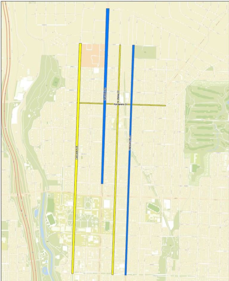
After several months of meetings and discussions, the committee developed a draft plan called A Pedestrian and Bicycle Safety Plan for the Old North End. The plan calls for concurrently “safety sizing” the four minor north-south arterial streets that run through the Old North End. They are N. Cascade Avenue, N. Nevada Avenue, N. Weber Street, and N. Wahsatch Avenue. The four streets would be safety sized from roughly the old Rock Island railroad track on the north to just south of Colorado College.
To develop our plan we used the traffic analysis contained in the 2013 Colorado College Transportation Master Plan. This plan was developed after a year long public input process that included several local stakeholders including ONEN Board Member and neighbors. It includes the most recent traffic analysis available for the streets included in the ONEN Safety Plan.
Safety sizing is designed to calm traffic through residential neighborhoods by reducing the number of traffic lanes from two-lanes-in-each-direction to one-lane-in-each-direction. Channeling the traffic in this way greatly increases pedestrian and bicycle safety on the streets, particularly at pedestrian crossings and intersections, without inhibiting the smooth flow of vehicle traffic.
Our plan also proposes safety sizing two east-west routes. One is Fontanero Street from N. Cascade Avenue to N. El Paso Street. The other is E. Uintah Street from east of N. Wahsatch Avenue to Shooks Run.
On March 10, 2016 The Board of Directors of the Old North End Neighborhood (ONEN) unanimously adopted A Pedestrian and Bicycle Safety Plan for the Old North End. At that point the Board of Directors began publicizing the plan and seeking feedback from the neighborhood and community.
A Pedestrian and Bicycle Safety Plan for the Old North End
Colorado College Transportation Master Plan
How did we get here – Perspectives from a Nevada Ave Neighbor
Open Letter from the President of ONEN
Email– Email your comments about the plan to info@oldnorthend.org . Your comments and questions will be responded to.
Feedback Received & ONEN Responses:
In Person/ Phone– If you wish to discuss the plan in person or by telephone, contact:
Bob Loevy (719) 640-5895
Pat Doyle (719) 473-8108
Prior Meetings:
ONEN Public meetings– Please join us to make your ideas and views known to the Old North End Neighborhood Board of Directors.
Saturday, April 9, 10 A.M. – 12 Noon- Tim Roberts, Senior Transportation Planner, represented the City at the meeting. Notes from Meeting #1
Tuesday, April 12, 7 P.M. – 8:45 P.M. Tim Roberts, Senior Transportation Planner, represented the City at the meeting. Notes from Public Meeting #2
First Lutheran Church, 1515 N. Cascade Avenue
Fellowship Hall (Basement)
Enter from the alley between Caramillo St and Buena Ventura St
City Public Meeting (Open House)
Tuesday. May 3rd, 2016 – 05:00 PM, City Auditorium
City Announcement – postcards were also mailed residents of affected streets
Map of Affected Streets: Click image for larger view
Notes from Open House (on facebook event)
City Right Sizing FAQs Handout
Safety sizing in residential neighborhoods – particularly historically preserved neighborhoods – has the following benefits:
• It lowers vehicle speeds and controls speeding. A single lane of traffic tends to move at a steady speed just above the speed limit. Speeders are no longer able to race around law-abiding drivers by using a second lane of traffic.
• It puts a stop to street racing, frequent lane changing, cars passing one another at high speed, and aggressive drivers manipulating to get ahead of all the other traffic. The tension of cars coming up from behind drivers and passing them closely in the second lane is eliminated. Middle-aged and older drivers are particularly rewarded by these improvements.
• It reduces automobile accidents in a range of 10 to 65 percent.
• The space originally used for a second lane of traffic in each direction can be used for left-turn lanes and right-turn lanes at busy intersections. This creates a pleasanter situation for motorists, as turning left or right from special “left turn” and “right turn” lanes is easier and safer than having to turn from a busy lane of moving traffic.
• With the second lane of traffic in each direction removed, there is additional space on the roadway for wide and safe bicycle lanes. It becomes much pleasanter and safer for bicyclists to pedal through the neighborhood.
• Pedestrian and bicycle safety is enhanced because, at intersections and pedestrian crossings, pedestrians and bicyclists only need to cross two lanes of active traffic (one northbound and one southbound). With two-lanes-in-each-direction, pedestrians and bicyclists have to cross four lanes of traffic on an arterial street. This benefit most likely would have prevented the January 2016 accident at Colorado College in which a student was hit, dragged along the street pavement, and seriously injured on two-lanes-in-each-direction N. Cascade Avenue.
• It improves the walkability and the pedestrian atmosphere in the neighborhood. The traffic calming effects of “One-Lane-From-Two” listed above for automobiles and drivers also create an improved feeling of safety on the street for pedestrians. There is less traffic noise (fast accelerations, fast stops with squealing brakes, horn honking, etc.). Walking about the neighborhood becomes a happier experience, and people feel more neighborly.
Safety Sizing Advocate
Jeff Speck is a city planner and urban designer who, through writing, public service, and built work, advocates internationally for smart growth and sustainable design. He recently spoke in Downtown Colorado Springs as part of the City Center Series. Jeff Speck City Center Series – Downtown Colorado Springs
Previous notable TED Talks by Jeff Speck:
Jeff Speck: The general theory of walkability
The ONEN Pedestrian and Bicycle Safety Plan highlights the point that traffic loads on the four major north-south arterial streets through the Old North End should be equally distributed. The Old North End Master Plan, adopted by the City Council in 1991, stated there should be “equitable distribution of traffic flow among existing arterial streets in the neighborhood, so that no one street is excessively overloaded with non-local traffic.” The Plan provides statistical data to demonstrate there is plenty of automobile capacity on the four arterial streets running through the Old North End to justify extensive use of “One-Lane-From-Two” traffic calming, even at peak traffic times during rush hour.
The Plan also contains an extensive study of the effects of one-lane-in-each-direction traffic on N. Nevada Avenue during railroad bridge repairs. In 2013 the City embarked on a major rebuilding of the N. Nevada Avenue bridge over the Rock Island railroad tracks, necessitating for several months the reduction of traffic in each direction on N. Nevada from two lanes to one. This study revealed that most of the traffic diverted from N. Nevada by bridge repairs went to parallel I-25 rather than N. Cascade Avenue.
The ONEN Pedestrian and Bicycle Safety Plan notes that safety sizing – reducing arterial streets from two-lanes-in-each-direction to one-lane-in-each-direction – is already practiced widely in Colorado Springs. You can drive on safety-sized streets at the following locations: